June 17, 2026 | Weather Alerts
UPDATE FROM STATE CLIMATOLOGIST, JAY GRYMES
Tropics Update: 10 AM Wednesday
Opinions are mine … the NHC and NWS offices serving Louisiana provide the federal weather expertise
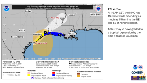
Potential Tropical Cyclone #1 (PTC01) earned the upgrade to T.S. Arthur effective at 10 AM.
The NHC is currently displaying Arthur as already capable of delivering TS-force winds into western Cameron Parish, with the system’s peak winds extending out over the Gulf by more than 150 miles.
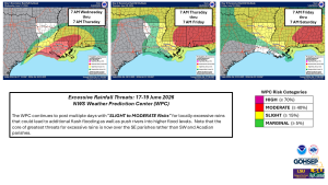
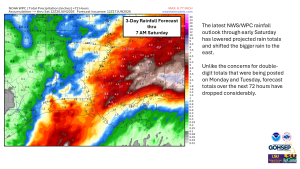
Flooding remains the primary concern … and southern Louisiana communities need to remain vigilant with regard to nuisance and flash flooding potentials for today, Thursday, and Friday. Some good news, however, is that WPC forecasted rain amounts have come down and the latest NWS guidance suggests that “reasonable worst-case scenarios” (10% chance) are less than 8″ for rain totals over the next 72 hours, with more likely numbers running in the 2″ to 5″ range for most areas.
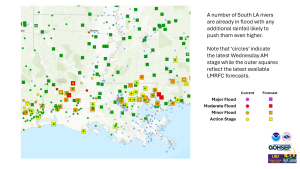
Given the regional saturation, that will still be enough to generate additional rises on several South Louisiana rivers.
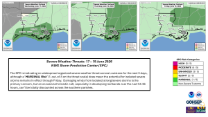
Peak winds will likely max-out in the 40-45 mph range (with higher gusts); worst-case numbers might go 45-55 mph. Regardless, these max winds won’t last long or extend very far inland. Indeed, the rainbands to the east of the core look like they could be the bigger problems, generating locally heavy downpours and potentially spawning an isolated tornado or two later today and into Wednesday night and Thursday.
Note that the SPC has a MARGINAL Risk for severe storms for portions of Louisiana for today, Thursday, and Friday.
Flood Watches remain in effect for most of the state and Louisiana parishes have seen a number of Flash Flood Warnings posted over the past two days. Plan for additional Flash Flood Warnings over the next 24-36 hours.
Coastal flooding will run 1-3 feet with inlets potentially reach 4 ft or more: manageable for the most part in the areas accustomed to wind-driven surges.
Emergency Managers and river residents should keep a close eye on local rivers over the next 3-5 days, although the dip in forecasted rain totals is certainly good news there.
Thanks/Courtesy:
Local NWS forecast offices serving LA: SHV, JAN, LCH & LIX
NWS Lower Mississippi River Forecast Center (LMRFC)
NWS Water Prediction Service
NWS Weather Prediction Center (WPC)
NWS Storm Prediction Center (SPC)
NWS Climate Prediction Center (CPC)
US Geological Survey (USGS)
TropicalTidbits.com
WeatherModels.com
GOHSEP & LSU