
August 12, 2026 | Weather Alerts
TROPICAL UPDATE FROM STATE CLIMATOLOGIST, JAY GRYMES 8.12.26
Tropics Watch: Wednesday AM
Opinion/comments are mine …
check with the federal experts at the NHC and the four NWS Field Offices serving LA: LIX, LCH, JAN & SHV
No significant changes or increase in threat for the Bayou State … at least for now.
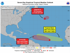
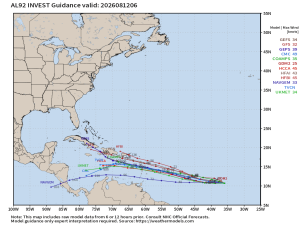
The NHC tagged the disturbance in the central tropical Atlantic as Invest 92L yesterday and model runs have been coming in. The ‘median’ forecast track for 92L has dipped farther south than I had expected, now taking the system towards the eastern Caribbean rather than to the north/northwest of the Antilles.
Development chances for 92L are set at 80%, indicating a good chance this becomes TD #4 (at least) and possibly (probably?) TS Dolly.
[Note: Invest 93L in the sub-tropical Atlantic gets the upgrade to Cristobal at 10:00 AM CDT today … obviously no threat to land.]
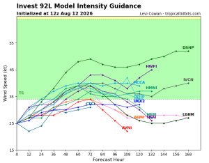
But models are not terribly bullish on 92L/td#4/Dolly surviving a trip through the eastern Caribbean … not all that unusual for low-riding systems in the first half of the season. A number of models depicted on the ‘spaghetti tracks’ and the ‘intensity forecast’ graphics suggest that 92L/TD#4/Dolly could dissipate in the 5-6 day time frame.
It is the tropical wave behind/east of 92L that seems to have a greater likelihood of surviving. The Google Deep Mind (GDM) forecast — included here — keeps it churning but turning northwest of the Antilles. To be clear, that’s just one model, but the GDM performed well in 2025 and generally reflects what several other models are displaying.
Thanks/Courtesy:
NOAA/National Hurricane Center (NHC)
NWS Offices serving Louisiana: SHV, JAN, LCH & LIX
WeatherModels.com
TropicalTidbits.com
WeatherNerds.org