
TROPICAL UPDATE FROM STATE CLIMATOLOGIST, JAY GRYMES 9.1.26
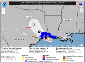
Max winds: 40 mph
Moving: WNW @ 8 mph
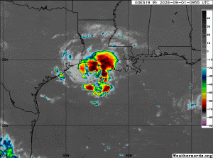
In spite of no overnight increase in maximum winds, the NHC is still VERY bullish on Edouard gaining strength between now and landfall (around 1PM-ish), with NHC max wind forecast at 65 mph as Edouard comes ashore. (Admittedly, that seems to be a very aggressive forecast given the 7AM status of Edouard.)
Most likely landfall to the west of the LA/TX border.
Edouard likely remains a very compact storm and should weaken quickly after landfall. However, that small size and some favorable aspects of the current environment (low shear, SSTs in the upper 80°s) have several regional hurricane models suggesting a big uptick in windspeeds over the next 6 hours (prior to landfall).
We may see 40-50 mph gusts in/near Lake Charles … but I expect sustained tropical-storm force winds (≥ 39 mph) to be limited to coastal & western Cameron Parish.
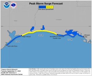
SW coast storm surge could go to 4-5 ft in spots but I think most of the coast gets 3 ft or less.
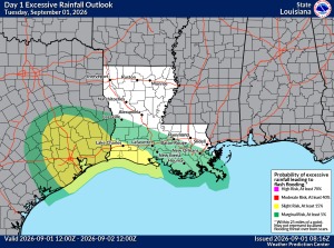
Southwestern parishes should be prepared for nuisance localized heavy downpours but no widespread rain-generated flooding. Expect less than 3” of rain for the SW coastal parishes … even less farther inland. The NWS/WPC has SW Louisiana under a “SLIGHT Risk” (1-out-of-4 threat) for rains to exceed flash flood guidance today.
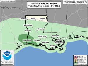
Tornado threats for the SW parishes are very low but not ‘zero’. The NWS/SPC has the SW corner of the state under a ‘MARGINAL Risk‘ (1-out-of-5 threat) for severe storms through the day.
National Hurricane Center (NHC)
WeatherNerds.org
WeatherBELL.com
WeatherModels.com
GOHSEP & LSU