WEATHER UPDATE FROM US NWS LAKE CHARLES 6.12.26
Good morning all,
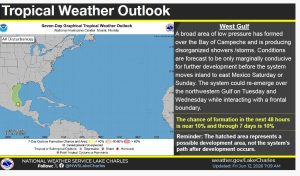
Attention certainly has turned to the Gulf rather quickly since the start of the hurricane season on the 1st. A disorganized area of low pressure has formed within the Bay of Campeche overnight. It is expected to move into Mexico this weekend with no tropical development likely. The disturbance is expected to hug the TX coastline as it’s pulled north by Gulf high pressure.
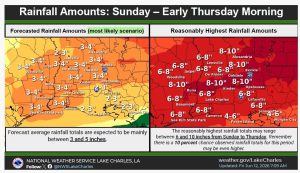
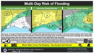
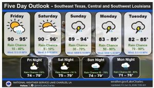
Tropical moisture surging northward over the weekend will interact with a boundary moving into the north Gulf states making for a focus of heavy rainfall from Sunday through at least Wednesday.
Waves of rainfall with high rain rates are anticipated and forecast totals 3 to 5 inches with locally higher amounts can be expected over this time. A Slight Risk of Excessive Rainfall (level 2 of 4) has been issued for portions of the area each day as well as the flooding risk increases with each subsequent wave.
Continue monitoring the forecast for the latest information.