
July 19, 2026 | Weather Alerts
TROPICAL UPDATE FROM JAY GRYMES, STATE CLIMATOLOGIST 7.19.26
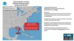
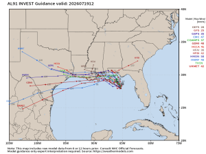
Sunday 7 AM: Invest 91L – things changed quickly!
Comments are mine … the NHC and local NWS forecast offices provide the federal weather expertise …
We still aren’t at any stage of ‘alarm’ … more in the ‘awareness & alert’ phase for now.
It has been a rapid shift in perspective for that “spin” in the eastern Gulf …
the NHC tagged the system as Invest 91L on Saturday afternoon with NHC 2-day development chances ramping up from 20% on Saturday morning to 80% for Sunday at 7 AM.
Most of the spin that you see on the satellite imagery is mid-level … but there are signs of a broad surface rotation which has the potential of tightening-up over the next day or two. Deep convection (t-storms) remain scattered and stretched across this broad low pressure area, but that could change quickly too.
NHC suggests that this could become Tropical Depression #2 within 24 hours.
Guidance is trending more and more to the west, raising the need for being alert here in the Bayou State. There is some computer guidance suggesting that northerly wind shear could limit storm development and keep much of the energy on the southern side of the system. That said, however, there is a decent chance we could be looking at the precursor of T.S. Bertha.
Any threat to Louisiana likely holds of until Tuesday or Wednesday, so you still have time to prep.
In the meantime … be extra careful in the heat & humidity over the next couple of days.
Whether the NWS issues Heat Advisories of not for your community, it will be brutally hot over the next couple of days.
Thanks/Courtesy:
National Hurricane Center (NHC)
NWS offices serving Louisiana: SHV, JAN, LCH, and especially LIX
weathernerds.org
tropicaltidbits.com
weathermodels.com
GOHSEP & LSU